
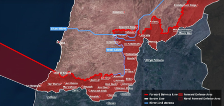
Israel’s military has unveiled a map detailing a “buffer zone” being established in southern Lebanon. This zone extends several kilometers into Lebanese territory, forming a continuous belt from Lebanon’s Mediterranean waters to the Mount Hermon area near the Syrian border. Prime Minister Benjamin Netanyahu and Defence Minister Israel Katz have affirmed that Israeli troops will remain in the area despite a temporary ceasefire that came into effect between Thursday and Friday local time. Katz mentioned that Israel plans to demolish houses and structures in the zone, similar to actions taken in the Gaza Strip, and issued a warning that Israeli forces would target individuals identified as Hezbollah members.
The military, with five divisions and naval forces, is currently active in Lebanese territory to create a “Forward Defense Line” aimed at countering direct threats to northern Israel’s communities. The map of the buffer zone includes a maritime segment off the Naqoura-Ras al-Bayada coastline, indicating a naval presence. It stretches north of key cities like Bint Jbeil, Aita al-Shaab, and Khiam, reaching the Litani River in certain areas, covering various villages and ridge lines. However, Lebanon and Syria have not approved of this move.
Despite the ceasefire, Israeli military operations intensified in southern Lebanon, as reported by Lebanon’s National News Agency. In Bint Jbeil, homes were being demolished to clear the security zone, with tanks patrolling the city. Additionally, houses were detonated in al-Bayada and al-Naqoura, roads were blocked using earth mounds, and the town of Kounine was shelled. There has been no immediate comment from Israel regarding these actions.
The release of the map follows Washington’s announcement of a 10-day ceasefire between Israel and Hezbollah, who have been engaged in deadly clashes since early March. Notably, during a previous ceasefire in November 2024, Israel continued its near-daily strikes in southern and eastern Lebanon.