
Close Menu
  • Indian Festivals 2026
  • Movie & OTT Releases This Week
  • Entertainment
  • NRI Life
  • Research
  • Advertise with us
Facebook X (Twitter) Instagram YouTube
  • Download Indian Community App
  • Advertise Here
Facebook X (Twitter) Instagram
Indian CommunityIndian Community
Trending
  • The Indian Head Wobble, Explained: What It Actually Means (And Why Almost No One Gets It Right)
  • Mirzapur The Movie Review 2026: Explosive Bhaukaal Saga Delivers Nostalgic Thrills
  • Romanchakam Movie Review 2026: A Delightful Youthful Romance That Wins Hearts
  • Immortal Movie Review 2026: A Bold Bat-Fantasy Horror That Bites Into New Territory
  • Yen Ennai Edho Seidhai Movie Review 2026: A Heartfelt Slice-of-Life Triumph Worth Watching
  • Jeevan Ya Bheema Con Review 2026: A Wildly Entertaining Mistaken-Identity Caper That Delivers Big Laughs
  • Mahaprabhu Jagannath Movie Review 2026: A Divine Animated Triumph Families Will Love
  • Gandhari Movie Review 2026: Taapsee Pannu Delivers a Gripping, Unmissable Thriller
  • Indian Festivals 2026
  • Entertainment
  • Latest Movie Releases
    • Latest OTT Releases
  • NRI Life
  • India & Culture
  • Health & Wellness
  • Research
Indian CommunityIndian Community
Home » News » National
National

Tamil Nadu to Map Coastal “Blue Carbon” Ecosystems Using Drones and AI

Indian Community Editorial TeamBy Indian Community Editorial TeamMarch 4, 20263 Mins ReadNo Comments Add us to Google Preferred Sources
Tamil Nadu to Map Coastal “Blue Carbon” Ecosystems Using Drones and AI
Share
Facebook Twitter LinkedIn Pinterest Email

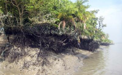
Tamil Nadu is embarking on a significant scientific project to map its coastal “blue carbon” ecosystems, including mangroves, seagrass meadows, and tidal marshlands, with the help of drones, Artificial Intelligence, and cloud computing. The initiative’s goal is to gather detailed data on the carbon stored in these ecosystems and create a comprehensive Blue Carbon Atlas for the state. This effort could potentially allow Tamil Nadu to engage in global carbon markets.

Current estimates indicate that Tamil Nadu boasts approximately 90 sq km of mangroves, 800 sq km of seagrass beds, and about 64 sq km of tidal marshlands. However, these figures are considered uncertain due to the lack of comprehensive mapping of these ecosystems. Existing data is primarily derived from limited field samples across vast coastal areas, leading to discrepancies between state and national estimates. Scientists emphasize the importance of precise measurements to scientifically validate and trade the carbon stored in these ecosystems on international carbon markets.

To address this challenge, researchers from the M.S. Swaminathan Research Foundation (MSSRF), in partnership with the Tamil Nadu Forest Department and technical assistance from Microsoft, have initiated a project to map these ecosystems in unprecedented detail. The head of GIS and remote sensing at MSSRF, R. Nagarajan, highlighted the significance of mangroves in storing carbon and expressed that the project would aid in identifying degraded areas for restoration, facilitating more targeted conservation efforts by the government.

The mapping endeavor will utilize advanced drones equipped with multispectral sensors to capture high-resolution imagery at a 2-5 centimeter scale, surpassing the resolution of previous satellite-based mapping. These sensors will enable scientists to analyze vegetation characteristics and classify different mangrove species more accurately. Additionally, Light Detection and Ranging (LiDAR) technology will be employed to measure canopy height, a critical parameter for estimating forest biomass. Integration of drone data with satellite imagery and ground samples will be conducted to validate the findings.

In the final phase, each pixel in the mapped imagery will be assigned a specific carbon value, facilitating precise calculations of above-ground and below-ground carbon stocks in mangrove ecosystems. The project will also encompass the mapping of tidal marshlands adjacent to mangrove habitats. While mapping seagrass meadows poses challenges due to limitations in drone detection capabilities underwater, key marine areas like the Gulf of Mannar and Palk Bay, which harbor extensive seagrass beds and support endangered dugongs, will be included in the survey.

Upon completion, the project will culminate in the development of both digital and printed versions of the Blue Carbon Atlas. This resource will serve as a valuable tool for policymakers and conservationists, aiding in the protection of coastal ecosystems and exploring opportunities for climate finance.

Artificial Intelligence Blue Carbon Atlas Carbon Markets Drones Dugongs Gulf of Mannar LiDAR M.S. Swaminathan Research Foundation Mangroves Microsoft Palk Bay Seagrass Meadows Tamil Nadu Tamil Nadu Forest Department Tidal Marshlands
Add us to Google Preferred Sources
Indian Community Editorial Team

The Indian Community Editorial Team curates, verifies, and publishes stories that matter to Indians worldwide. From culture and community to business and innovation, our mission is to spotlight voices, ideas, and events that bring our global community closer together. Have news or a story to share? Submit it to us at [email protected].

Related Posts

How Can Businesses Evaluate AI ROI Beyond Traditional Metrics? Strategies Most Companies Still Overlook

Add A Comment

Piyush Soni: The Chokra Singer’s Journey Back to Music

August 24, 2026

Formula 1: Max Verstappen pens contract extension with Red Bull till 2030

August 20, 2026

Prakash Raj to play revered carnatic music maestro in ‘Jagamae Sangeetham’

August 20, 2026

Three in four occupiers plan to expand their office portfolios in India over next two years

August 20, 2026
  • Facebook
  • Twitter
  • Pinterest
  • Instagram
About Us
  • About Us
  • Contact Us
  • Terms of Service
Corporate
  • Download Indian Community App
  • Advertise Here
Facebook X (Twitter) Instagram
  • About Us
  • Contact Us
  • Terms of Service
© 2026 Designed by CreativeMerchants.

Type above and press Enter to search. Press Esc to cancel.