Close Menu
  • Indian Festivals 2026
  • Movie & OTT Releases This Week
  • News
  • Entertainment
  • NRI Life
  • Research
  • Advertise with us
Facebook X (Twitter) Instagram YouTube
  • Download Indian Community App
  • Advertise Here
Facebook X (Twitter) Instagram
Indian CommunityIndian Community
Trending
  • Vanki Chuki Love Story Review – A Heartfelt Gujarati Romantic Drama That Celebrates Love, Family & Wedding Magic
  • Mathe Male Hoyyuthide Review: A Heartfelt Generational Love Story Set in the Rains of Malenadu
  • M4M – Motive for Murder Review: A Gripping Telugu Crime Thriller That Turns Murders into Masterpieces
  • Ankam Attahasam Movie Review (2026): Madhav Suresh’s Gritty Trivandrum Gangster Drama Is a Raw, Riveting Ride
  • Citadel Season 2 Review (2026): Priyanka Chopra, Richard Madden & Stanley Tucci Make This Prime Video Thriller Unmissable
  • Dridam Movie Review: Shane Nigam’s Slow-Burn Cop Drama Is Gripping — Until It Isn’t
  • 29 Movie Review: A Heartfelt Romantic Drama That Blooms in Its Own Time
  • Razor Movie Review (2026): Ravi Babu Delivers a Gripping Survival Thriller
  • Indian Festivals 2026
  • News
    • National
    • International
    • Entertainment
    • Achievements
    • Scam Alerts
    • Business
    • Health & Medicine
    • Science & Technology
    • Sports
  • Entertainment
  • Latest Movie Releases
    • Latest OTT Releases
  • NRI Life
  • India & Culture
  • Health & Wellness
  • Research
Indian CommunityIndian Community
Home » News » International
International

US-India Satellite Captures Detailed Image of Mississippi River Delta Region

Indian Community Editorial TeamBy Indian Community Editorial TeamJanuary 30, 20262 Mins ReadNo Comments Add us to Google Preferred Sources
US-India Satellite Captures Detailed Image of Mississippi River Delta Region
Share
Facebook Twitter LinkedIn Pinterest Email

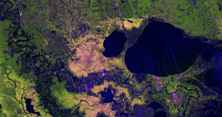
A high-resolution radar image captured by the US–India NISAR Earth-observing satellite showcases the Mississippi River Delta region in southeastern Louisiana. The image, taken on November 29, 2025, reveals intricate details of urban areas, wetlands, forests, and farmland in one of the United States’ most intricate landscapes. NISAR’s L-band synthetic aperture radar instrument depicted New Orleans, the Mississippi River, Lake Pontchartrain, and surrounding ecosystems using radar signals that vary based on surface type and structure.

NISAR, a collaborative effort between NASA and the Indian Space Research Organisation, highlights the longstanding cooperation between the US and India in Earth science and satellite research. The image’s resolution allows for the clear identification of the Lake Pontchartrain Causeway, the world’s longest continuous bridge over water, stretching nearly 24 miles. The Mississippi River meanders across the image from Baton Rouge to New Orleans, with vibrant green areas west of the river indicating healthy forests where radar signals interact differently due to dense vegetation.

In contrast, the Maurepas Swamp, situated west of Lake Pontchartrain and Lake Maurepas, displays mottled yellow and magenta tones, signifying thinning tree populations in the wetland forest ecosystem. The image also reveals parcels of farmland on both sides of the Mississippi, with varying shapes and brightness. Darker areas represent fallow fields, while bright magenta patches indicate the presence of tall plants like crops.

The technical capabilities of NISAR’s radar systems are evident in the image. The L-band instrument, with a 9-inch wavelength, penetrates forest canopies to measure soil moisture and land movement with high precision. Additionally, NISAR carries an S-band radar provided by the Indian Space Research Organisation’s Space Applications Centre, which uses a shorter 4-inch wavelength ideal for monitoring agriculture and grasslands. Launched in July 2025, NISAR aims to collect global data to enhance scientists’ understanding of Earth’s surface, ice, and ecosystems, supporting disaster response with rapid before-and-after observations.

Baton Rouge Earth science Indian Space Research Organisation L-band Lake Maurepas Lake Pontchartrain Louisiana Maurepas Swamp Mississippi River Delta NASA New Orleans NISAR S-band satellite research United States
Add us to Google Preferred Sources
Indian Community Editorial Team

The Indian Community Editorial Team curates, verifies, and publishes stories that matter to Indians worldwide. From culture and community to business and innovation, our mission is to spotlight voices, ideas, and events that bring our global community closer together. Have news or a story to share? Submit it to us at [email protected].

Related Posts

U.S.-India Trade War: What Happens if a 500% Tariff is Imposed?

Add A Comment

Kevin Hart Expresses Love for Wife Ahead of 10th Anniversary

May 12, 2026

Gujarat Titans post 168/5 against Sunrisers Hyderabad in IPL match

May 12, 2026

Shabnim Ismail Returns to South Africa Squad for ICC Women’s T20 World Cup

May 12, 2026

Sorana Cirstea advances to Italian Open 2026 semifinals with win over Jelena Ostapenko

May 12, 2026
  • Facebook
  • Twitter
  • Pinterest
  • Instagram
About Us
  • About Us
  • Contact Us
  • Terms of Service
Corporate
  • Download Indian Community App
  • Advertise Here
Facebook X (Twitter) Instagram
  • About Us
  • Contact Us
  • Terms of Service
© 2026 Designed by CreativeMerchants.

Type above and press Enter to search. Press Esc to cancel.