


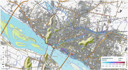
The Real Time Governance Society (RTGS) of Andhra Pradesh, in partnership with the State Disaster Management Authority and IIT Gandhinagar, has introduced a cutting-edge forecasting system. This platform offers a 48-hour rainfall outlook and six-hour flash flood warnings, starting in Vijayawada. The City Flood Alert tool predicts urban flooding in advance, empowering authorities to take preventive measures.
Integrating artificial intelligence, satellite mapping, predictive analytics, and hydrological modeling, the system provides accurate flood forecasts and real-time warnings for urban areas. Launched under Chief Minister N. Chandrababu Naidu’s vision, this initiative demonstrates the state’s commitment to utilizing technology for disaster management and enhancing urban resilience.
Vijayawada, a rapidly growing city in Andhra Pradesh, faces recurrent floods, especially from the Budameru stream during heavy rainfall. To address this, RTGS has developed the City Flood Alert platform. This tool identifies at-risk areas, forecasts flood risks, and alerts officials automatically before flooding occurs.
The platform offers rainfall forecasts up to 48 hours in advance, flash flood predictions up to six hours before, and flood hotspot identification at the ward level. It also provides early warning alerts to officials and real-time decision support for emergency responses. By leveraging a high-resolution Digital Elevation Model, the system accurately maps flood-prone areas and drainage networks.
When a potential flood threat is identified, the platform generates alerts for the State Disaster Management Authority. This enables timely warnings and advisories to municipal and district officials, facilitating preventive measures like clearing drainage channels and deploying emergency response teams. The technology-driven approach transforms disaster management into a proactive governance model.
Initially operational in Vijayawada, the platform will expand to all Urban Local Bodies in Andhra Pradesh. Each city will undergo digital terrain mapping and flood-risk assessment, creating a network of intelligent urban flood monitoring systems for precise forecasts and alerts.
