
The Regional Meteorological Centre predicts ongoing early morning fog in Chennai and eight neighboring districts, alongside anticipated moderate rainfall in parts of Tamil Nadu. Despite the weakening of a low-pressure system formed over the Bay of Bengal, residual effects combined with prevailing atmospheric conditions are expected to bring moderate rain to select areas in southern Tamil Nadu and northern districts on Wednesday. Puducherry and its Karaikal region are also likely to witness light to moderate rainfall, with the forecast suggesting continued rainfall activity across Tamil Nadu until March 1.
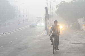
Weather officials attribute the unsettled conditions to changing wind patterns and moisture influx from the sea. Residents of Chennai, Tiruvallur, Kancheepuram, Salem, Dharmapuri, Krishnagiri, Tirupattur, Vellore, and Ranipet districts are advised to brace for light fog during early morning hours on Wednesday and Thursday, potentially affecting visibility in interior areas and along highways. Authorities caution motorists to exercise caution during dawn hours.
In addition to the anticipated rainfall and fog, the Meteorological Department anticipates a rise in daytime temperatures. Until February 28, maximum temperatures in Tamil Nadu and Puducherry are expected to be 2 to 3 degrees Celsius above normal. This combination of above-normal daytime heat and misty mornings reflects the current transitional weather pattern in the region.
Although the low-pressure area has weakened, weather experts highlight the possibility of sporadic showers due to localized convection and moisture availability. Farmers and residents in rain-fed regions are advised to stay updated on local forecasts. With fluctuating weather conditions expected to persist, the Meteorological Department assures regular updates and advisories as necessary.