
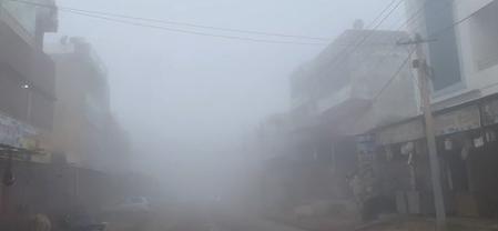
Jaipur experienced light drizzle on Tuesday, while the rest of Rajasthan remained dry. However, several areas in the state faced moderate to dense fog during the early morning hours, affecting visibility. Temperatures varied widely across Rajasthan, with Jawai Dam in Pali district recording the highest maximum temperature at 30.4 degrees Celsius and Pali (AWS) registering the lowest minimum temperature at 4.6 degrees Celsius.
A strong Western Disturbance is expected to become active over parts of Rajasthan between January 22 and 24, potentially bringing winter rains. The Jaipur Meteorological Centre Director mentioned the likelihood of another Western Disturbance affecting the region between January 26 and 28, which could impact temperature patterns and precipitation.
On January 22, light to moderate rainfall with thunderstorms and lightning is forecasted for some parts of Jodhpur and Bikaner divisions, as well as the Shekhawati region. Similar weather conditions are expected on January 23 in the Bikaner division, Shekhawati region, and parts of Jaipur, Ajmer, and Bharatpur divisions, increasing the chances of widespread winter showers.
Following this, the weather is predicted to become relatively dry on January 24 and 25, with most areas experiencing clear conditions. However, a decrease of 2 to 4 degrees Celsius in minimum temperatures is likely during this period, along with the formation of dense fog at isolated places, especially during late night and early morning hours.
The Meteorological Centre has advised caution, particularly during foggy conditions that could impact road and rail travel. Farmers are also urged to stay vigilant as the anticipated winter rainfall could benefit Rabi crops in many regions.