
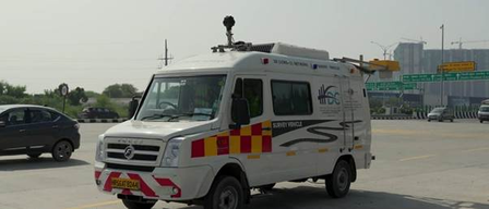
The Ministry of Road Transport and Highways has launched advanced Network Survey Vehicles (NSVs) equipped with 3D laser technology nationwide. These high-tech vehicles, featuring laser profilers, GPS systems, high-resolution cameras, and 3D laser sensors, are designed to create detailed digital maps of road conditions. The system can detect issues like potholes, cracks, and uneven surfaces, facilitating prompt corrective actions.
The initiative aims to enhance road safety and improve the overall riding experience on India’s National Highway network. These NSVs have already been deployed on various National Highway routes and are set to revolutionize the monitoring and maintenance of road assets. Unlike traditional methods that covered limited distances per day, these new vehicles can survey up to 300 kilometers daily, significantly boosting efficiency.
This enhanced efficiency is expected to speed up the identification of road defects and reduce maintenance intervention time, as per the ministry. Additionally, the technology streamlines data processing and reporting, with survey data being encrypted and sent to a central NSV center within 48 hours. Expert teams in five zones analyze the data promptly, shortening the entire process from months to just 10 days.
The new system ensures accuracy through a stringent quality assurance process before issuing automated notices to stakeholders via digital platforms. Furthermore, it integrates with the National Highways Authority of India’s AI-based Data Lake portal, enabling real-time analysis of road conditions for evidence-based maintenance and repair strategies.