


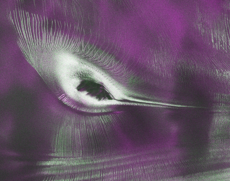
A joint US-India Earth-observation satellite, NISAR, has started sharing data from its radar instruments, providing a unique perspective on global changes. The satellite’s data, accessible to the public since July 20, offers insights into various Earth features, including an Antarctic landscape resembling a hummingbird.
Scientists in the US and India will continue to release processed files from NISAR’s L-band and S-band radars, aiding in tracking land and ice movements, monitoring forests and wetlands, and responding to natural hazards like earthquakes and landslides.
NISAR, launched from India’s Satish Dhawan Space Centre in 2025, has been actively monitoring Earth’s surfaces, calibrating instruments, and enhancing processing algorithms over the past year.
The latest data release includes an image of Nunatak Zaterjavshijsja in East Antarctica, showcasing a mountaintop surrounded by ice flowing towards the ocean, forming a hummingbird-like shape. The radar image reveals deep crevasses as green lines and smoother ice surfaces as magenta, offering detailed insights into the glacier’s movements.
NISAR’s unique ability to penetrate snow and ice surfaces allows it to observe Antarctic ice properties not visible in optical imagery, providing valuable information on the hidden features beneath the surface.
The satellite’s data, collected through polarised microwave signals, reflects different interactions with the ice, with magenta indicating smoother surfaces and green representing irregular surfaces like crevasse walls.
ISRO’s Space Applications Centre and US teams have begun releasing S-band and L-band data, respectively, through dedicated portals, enhancing the accessibility of NISAR’s observations. The mission, generating significant amounts of science data daily, scans Earth from the South Pole to the Arctic Circle, utilizing a large 12-meter radar antenna reflector.
NISAR, a collaborative effort between NASA and ISRO, marks a milestone in US-India space cooperation, leveraging synthetic aperture radar technology to monitor Earth’s surface changes accurately.
The satellite’s unique capability to observe through cloud cover and darkness enables it to detect gradual surface movements and rapid changes caused by natural events like earthquakes, landslides, and floods.
