
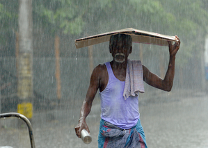
The Regional Meteorological Centre in Chennai has predicted moderate rainfall in various parts of Tamil Nadu, especially in the Western Ghats districts and coastal areas of southern Tamil Nadu. A low-pressure trough at an altitude of about 0.9 km above sea level is causing this weather pattern, stretching from north interior Karnataka to the Gulf of Mannar through south interior Karnataka and Tamil Nadu.
Meteorologists anticipate widespread rainfall across multiple districts in the state due to this atmospheric condition. The weather department expects light to moderate rainfall with thunderstorms and lightning in isolated areas along the Western Ghats districts, coastal regions, delta areas, and Karaikal region. These weather conditions are likely to persist throughout the day with intermittent rain spells in vulnerable areas.
Heavy rainfall is forecasted for the Nilgiris and Coimbatore districts over the next three days, potentially leading to localized disruptions in hilly and nearby regions. Residents in these districts are advised to be cautious, especially in landslide-prone or waterlogged areas. Additionally, Erode, Salem, Dharmapuri, and Krishnagiri districts are also expected to experience heavy rainfall in the next two days.
As the weather system moves southward, more districts will be affected. On May 1, Tiruppur, Dindigul, and Theni districts may experience isolated heavy rainfall, with the intensity continuing on May 2. Parts of Dindigul, Theni, Madurai, Sivaganga, and Virudhunagar districts are expected to receive heavy rainfall on May 2 as well. Authorities are urging local administrations to stay vigilant, especially in flood-prone areas, while fishermen are cautioned about adverse weather conditions along the southern coast.
Despite the southwest monsoon being weeks away, the current rainfall is due to localized atmospheric instability rather than seasonal monsoon activity.